
Florida property records contain different codes that help classify properties, identify assessment categories, and organize county property information. However, many users find these codes confusing because reports often display numbers or short abbreviations instead of complete descriptions. FL Parcel Point provides access to property code information across all 67 Florida counties. This guide explains the available code fields, what they represent, and how you can use them when reviewing a property’s public records.
How to Find Property Codes in Florida
To find property codes, visit the relevant Florida county page on FL Parcel Point and open its property search tool. You can search using the property’s parcel number, owner’s name, physical address, ZIP code, or city. If you have more specific information, you can also use Advanced Search to locate the correct property.

After finding the property, open its report and look for the Codes & Classifications section. This section contains 15 fields related to property use, assessment classifications, special circumstances, homestead status, geographical classifications, and tax authority information.
What Information Is Available in the Property Codes Section?
The Codes & Classifications section contains different types of codes used in Florida property data. Some fields identify how a property is classified for assessment purposes, while others relate to special circumstances, parcel changes, disaster information, or administrative classifications.
You may see numerical values, abbreviations, or blank entries depending on the available property records. These codes should not be interpreted using one universal definition because their meanings can depend on the applicable county or source dataset. Below, we explain all 15 fields and how you can use them when researching a property.
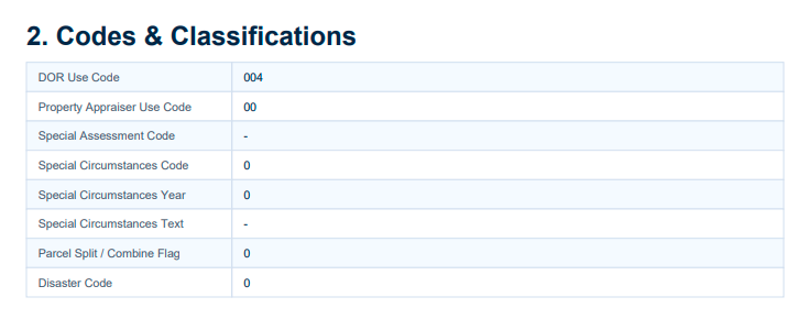
15 Property Codes and Classifications Explained
1. DOR Use Code
DOR Use Code is a property classification code associated with the Florida Department of Revenue’s property use reporting system. It helps categorize properties according to their recorded use classification in the assessment data. The report may display a numerical code rather than a written property description. This field may be unavailable when the source record does not contain a classification. You can use it to investigate how a property is categorized, but check the applicable Florida DOR code definitions before interpreting its exact meaning.
2. Property Appraiser Use Code
Property Appraiser Use Code identifies the use classification recorded by the county Property Appraiser for a particular property. It is a separate field from the DOR Use Code, so the two should not automatically be treated as identical. Its value may be different depending on the county’s classification records. You can use this code when researching how the local Property Appraiser categorizes a property. If you need its exact description, refer to the applicable county’s official use code reference.
3. Special Assessment Code
Special Assessment Code is a classification field associated with special assessment information in the property’s records. It may help identify whether a particular special assessment category or condition is recorded for the parcel. The field may display a dash when no value is available in the report. You can use it as a reference when reviewing property assessment information, but the exact meaning of a particular code should be confirmed through the relevant county’s assessment documentation.
4. Special Circumstances Code
Special Circumstances Code identifies a coded entry associated with special circumstances recorded for a property. It is designed to represent a particular classification rather than provide a complete written explanation. A report may display a numerical value, and its interpretation depends on the applicable dataset definitions. This field may be unavailable when no code is supplied. You can use it to identify records that may require additional review of special property circumstances through the county’s official records.
5. Special Circumstances Year
Special Circumstances Year displays the year associated with the special circumstances information recorded in the property dataset. It helps connect a special circumstances entry with its relevant reporting period. The field may contain zero or remain unavailable when a corresponding year is not recorded. You can use it alongside Special Circumstances Code and Special Circumstances Text to investigate the timing of a recorded condition, rather than assuming that the displayed year represents the property’s construction or sale year.
6. Special Circumstances Text
Special Circumstances Text provides a text-based description associated with the special circumstances recorded in the property data. Unlike the numerical code, this field may offer additional context about the classification. It can be blank or display a dash when no explanatory text is available. You can use it alongside the Special Circumstances Code and Special Circumstances Year to understand the recorded entry more clearly. If no text appears, check the applicable county records for further information.
7. Parcel Split / Combine Flag
Parcel Split / Combine Flag is a field associated with changes involving the division or combination of property parcels. It helps identify a recorded indicator related to parcel split or combination activity in the dataset. Its value may be represented by a numerical flag rather than a written explanation. You can use it when researching parcel changes or comparing property identification records over time. However, the exact meaning of each flag value should be confirmed through the source dataset documentation.
8. Disaster Code
Disaster Code is a classification field associated with disaster-related information in the property record. It may identify a recorded disaster-related code for a particular parcel, depending on the information supplied by the source dataset. This field may display zero or remain unavailable when no corresponding code is recorded. You can use it as an additional reference when reviewing disaster-related property information, but it does not independently confirm that a property has experienced physical damage.
9. Disaster Year
Disaster Year identifies the year associated with a disaster-related entry in the property dataset. It should be reviewed alongside Disaster Code because the two fields provide related classification and year information. The field may contain zero or no value when a corresponding disaster year is not recorded. You can use it when investigating the timing of a recorded disaster-related entry, but it should not be treated as proof of the exact date or extent of property damage.
10. Homestead Applicant Status
Homestead Applicant Status is a field related to the applicant information recorded for a property’s homestead classification. It provides a reference to the applicant status available in the property dataset. The field may display an abbreviation, code, or no value depending on the source record. You can use it when reviewing homestead-related property information, but it should not independently be treated as confirmation that a Homestead Exemption has been approved or is currently active.
11. Homestead Co-Applicant Status
Homestead Co-Applicant Status relates to the co-applicant information associated with a property’s homestead record. It is separate from the primary Homestead Applicant Status field and should be reviewed independently. Its value may be unavailable when no co-applicant information is recorded or supplied in the dataset. You can use it to investigate the available co-applicant information, but for confirmation of current exemption approval or eligibility, check the relevant county Property Appraiser’s official records.
12. Market Area Code
Market Area Code is a numerical classification used to identify a market area associated with a property in the assessment dataset. It helps organize property records according to the applicable market area classification. The displayed number may differ from one property to another, and the field may be unavailable when no code is supplied. You can use it when comparing property records within the same market area, provided you have access to the relevant county’s market area definitions.
13. Neighborhood Code
Neighborhood Code identifies a coded geographical neighborhood classification associated with a property in the county assessment data. It helps group properties into designated neighborhood areas for property assessment and record organization. The field may display a numerical reference rather than the neighborhood’s actual name. You can use it to compare properties within the same recorded neighborhood classification. To identify the exact geographical area represented by a code, consult the applicable county Property Appraiser’s records.
14. Public Land Flag
Public Land Flag is a classification field associated with public land information in the property dataset. It provides an indicator that may be used to identify a public-land-related record or classification. The field may display a dash when no value is available in the report. You can use it as an additional reference when researching how a parcel is categorized in county records. However, do not treat this flag alone as legal proof of public ownership or private ownership.
15. Tax Authority Code
Tax Authority Code identifies a numerical reference associated with the taxing authority information recorded for a property. It can help connect a property record with the applicable tax authority classification in the source dataset. The displayed code may differ between properties depending on their location and tax jurisdiction. You can use it when researching the taxing authority associated with a parcel, but check the relevant county or tax authority reference to identify the exact jurisdiction represented by the code.
Conclusion
Property codes help organize Florida property records and provide additional information about how individual parcels are classified. FL Parcel Point brings these 15 code-related fields together in one report, making it easier to review property use classifications, special circumstances, homestead-related information, and other administrative references across all 67 Florida counties. Understanding these fields helps you read property reports more confidently and identify which codes may require further verification through official county records.
Frequently Asked Questions
1. Why do property reports display numbers instead of written code descriptions?
Property datasets often store classifications as numerical codes to organize and process large amounts of information. Instead of displaying a complete description for every classification, the report may show the assigned code. To understand its exact meaning, you may need to consult the applicable county or Florida Department of Revenue code reference.
2. Are DOR Use Codes and Property Appraiser Use Codes the same?
No. Both fields relate to property use classifications, but they come from different classification references within the property data. A DOR Use Code is associated with the Florida Department of Revenue reporting system, while a Property Appraiser Use Code relates to the county’s property classification records. Their values and definitions should be checked separately.
3. Does a Homestead Applicant Status mean the property has an approved exemption?
Not necessarily. Applicant status information and an approved Homestead Exemption are not the same thing. A property report may contain homestead-related applicant information without independently confirming the current approval or active status of an exemption. You should check the county Property Appraiser’s records for official confirmation.
4. Can I use property codes to identify changes in a parcel?
Some fields can help you investigate recorded parcel changes. For example, Parcel Split / Combine Flag is associated with parcel division or combination information. However, a code alone may not explain the complete history of a property. You should compare available parcel records and consult official county documentation when researching a specific parcel change.
5. Where can I find the official meaning of a Florida property code?
The correct source depends on the type of code. For DOR-related classifications, you can consult the Florida Department of Revenue’s property tax and data documentation. For county-specific classifications, market area codes, neighborhood codes, and other local references, check the relevant county Property Appraiser’s official resources.