
Before reviewing property parcel details, it is important to understand what these records contain and how to use them. FL Parcel Point allows you to search property records across all 67 Florida counties. Many users confuse parcel numbers with other property identification codes or do not know where to find them. This guide explains each available field and its purpose.
How to Find Property Parcel Details
FL Parcel Point provides the same six search options across all 67 Florida counties. You can use any of these options to locate a property and access its parcel identification information. First, visit the relevant Florida county page and open its property search tool. Depending on the information available to you, choose one of the following search options:

- Parcel Number: Enter the property’s parcel number to locate its record.
- Owner Name: Search using the registered property owner’s name.
- Address: Enter the property’s physical street address.
- ZIP Code: Find properties within a specific postal area.
- City: Search for properties located in a particular city.
- Advanced Search: Use additional search criteria to narrow down your results.
After entering your search information, review the matching properties and select the correct record to open its complete property report.
Switch to the Parcel Details Section in the Report
When you search for a property, the report provides several categories of information, including ownership, building details, assessment values, and sales history. To focus on property identification, open the Parcel & Identification section of the report. This section contains 16 parcel-related fields that help you understand how a property is identified and referenced in county records. Continue reading to learn what each field means and how you can use it.
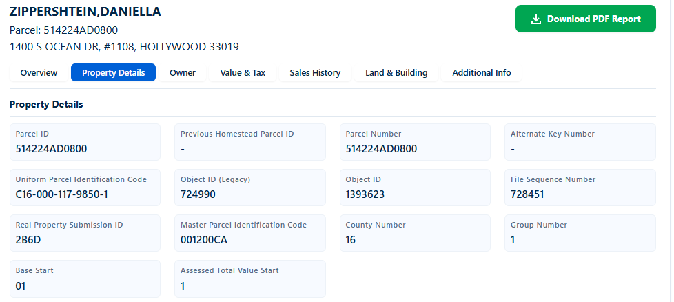
16 Parcel Details Fields Explained
1. Object ID
Object ID is an identification number assigned to a property record within the source dataset. In the example report, this field displays 1393623. It helps distinguish one record from another within the dataset. This number may be missing if the source record does not contain an assigned identifier or the field is unavailable. You can use it when referencing or comparing records within the same property data system.
2. County Number
County Number identifies the numerical county code associated with the property record. In the sample report, the value is 16. This is a coded identifier rather than the county name itself. It may be missing when county identification information is unavailable in the source record. You can use this number as a reference when reviewing county-level property datasets, although you should consult the applicable county code reference to identify its exact county designation.
3. Parcel ID
Parcel ID is an identification number used to reference a specific property parcel in the county’s property records. The example report displays 514224AD0800. This number helps distinguish the property from other parcels and can be useful when searching or comparing records. It may be unavailable if the source dataset does not contain the identifier. You can use it as a property reference when researching a parcel through available county records.
4. File Type
File Type displays a classification value associated with the property record in the source dataset. In the example, the report shows R. This is a coded field, so its exact meaning should be confirmed through the applicable county or dataset documentation rather than assuming what the letter represents. It may be blank when the source does not provide a value. You can use it when reviewing the record’s technical classification alongside other parcel information.
5. Assessment Year
Assessment Year identifies the year associated with the property’s assessment record. In the sample report, this field displays 2025. It helps you understand which assessment period the reported parcel information relates to. This field may be missing when the assessment year is not supplied in the available dataset. You can use it to distinguish records from different assessment years and avoid comparing property information from different periods without checking the dates.
6. Base Start
Base Start is a technical field included in the parcel identification section of the report. The sample record displays 01. Its exact purpose and coding definition are not explained in the report, so the value should not be interpreted as a property address, parcel number, or assessment amount. It may be unavailable when the source record does not contain this value. You can reference it when comparing the original dataset with its field definitions.
7. Assessed Total Value Start
Assessed Total Value Start is a technical data field displayed alongside other parcel identification details. In the sample report, its value is 1. The report does not provide a definition explaining what this starting value represents, so it should not be confused with the property’s actual assessed value. It may be missing when the source dataset does not supply it. You can use it as a reference when checking the underlying record structure and data documentation.
8. Group Number
Group Number displays a numerical grouping value associated with the property record. The example report shows 1. This is a dataset-related classification field, and its exact grouping rules are not provided in the report. It may be missing when the source record does not include a group assignment. You can use this value when reviewing related records or comparing entries within the same dataset, provided you have the applicable grouping definitions.
9. Previous Homestead Parcel ID
Previous Homestead Parcel ID identifies a parcel reference associated with a property’s previous homestead record, when such information is available. The sample report displays a dash (-), meaning no value is shown in this field. It may be missing because there is no previous homestead parcel reference recorded or the information is not included in the dataset. You can use this field when researching historical homestead-related parcel information and reviewing changes between property records.
10. Parcel Number
Parcel Number displays the parcel identification reference used to locate a property in county records. In the example, the value is 514224AD0800, matching the Parcel ID shown earlier. This field may be unavailable if the source record does not include a parcel number. You can use it when searching for a property, communicating with the county property appraiser, or checking whether another property record refers to the same parcel.
11. Alternate Key Number
Alternate Key Number is an additional identification reference that may be associated with a property record. It provides another possible way to reference the parcel apart from its primary parcel identification number. The sample report displays a dash (-), indicating that no value is shown. This field may be missing when no alternate key is assigned or supplied. You can use it when cross-referencing property records if an alternate identifier is available.
12. Uniform Parcel Identification Code
Uniform Parcel Identification Code is a coded property reference displayed in the parcel identification section. The sample report shows C16-000-117-9850-1. It provides another identification format for referencing the property within the applicable data system. This field may be missing when the source dataset does not contain a code. You can use it as an additional reference when comparing parcel records and checking property identification information.
13. Object ID (Legacy)
Object ID (Legacy) displays an older object identification reference associated with the property record. In the sample report, the value is 724990. This field is useful for distinguishing an earlier record identifier from the current Object ID. It may be missing when no legacy identifier is available in the source dataset. You can use it when comparing older property data with current records or tracing references across different versions of a dataset.
14. File Sequence Number
File Sequence Number displays a numerical reference associated with the property’s entry in the source file. The sample report shows 728451. It helps identify the record’s sequence within the applicable data file or record structure. This value may be missing when the source does not provide a sequence reference. You can use it when reviewing dataset entries, comparing exported records, or locating a particular entry in the underlying property data.
15. Real Property Submission ID
Real Property Submission ID is an identification reference included in the real property data submitted to the applicable property data system. The example report displays 2B6D. Its exact assignment and tracking rules depend on the source dataset documentation. It may be missing if the submission reference is not available in the record. You can use it as an additional technical reference when reviewing or cross-checking real property data submissions.
16. Master Parcel Identification Code
Master Parcel Identification Code displays a reference associated with the master parcel identification structure. In the sample report, this field shows 001200CA. It may help distinguish a master parcel reference from other parcel-level identifiers, although its exact relationship to individual parcels depends on the applicable dataset definitions. It may be missing when no master code is supplied. You can use it when reviewing parcel relationships and comparing related property records.
Conclusion
Understanding parcel details helps you identify a property more accurately and make better use of Florida public property records. FL Parcel Point provides access to parcel identification information across all 67 Florida counties, allowing you to review different property identifiers in one report. Whether you are researching a property, checking its parcel number, or comparing county records, knowing what these fields represent makes the search process easier and more useful.
Frequently Asked Questions
1. Are Parcel ID and Parcel Number always the same?
Not necessarily. Some property datasets display Parcel ID and Parcel Number as separate fields, even when both contain the same value. In the sample FL Parcel Point report, both fields display 514224AD0800. However, you should check the actual values in each property report instead of assuming they will always match across every county or dataset.
2. Can I search for a Florida property using only its parcel number?
Yes. If you know the property’s parcel number, you can select the Parcel Number search option in the relevant county’s FL Parcel Point tool. Enter the available number and review the matching results. Make sure you enter the correct parcel reference because even a small difference in letters or digits can affect your search results.
3. Why does one property report contain multiple identification numbers?
A property report can contain several identification numbers because different fields serve different referencing purposes within property datasets. Some identify the parcel, while others relate to source records, older identifiers, or additional data structures. These numbers should not automatically be treated as interchangeable. Check the field names and their corresponding values when comparing property records.
4. Can a property’s parcel number change over time?
A parcel identification number can change when property records are updated or when a parcel undergoes changes such as subdivision or combination. However, this depends on the county’s parcel identification practices and the specific property record. If you are researching an older property record, compare the available parcel references and consult the county property appraiser when you need to confirm a historical parcel connection.
5. Does a parcel identification record prove who legally owns a property?
No. Parcel identification details help you locate and reference a property, but they do not independently establish legal ownership. To review the registered owner, check the Owner Information section of the property report. For legal verification, you may also need to review official recorded documents maintained by the appropriate county office.